On the morning of January 13th, according to information from the Earthquake Information and Tsunami Warning Center - Institute of Geophysics, at 00:05 (Hanoi time) on January 13th, an earthquake with a magnitude of 2.8 on the Richter scale occurred at coordinates (21.21 degrees North latitude, 99.46 degrees East longitude), with a focal depth of approximately 10 km.
An earthquake occurred in Luong Son district, Hoa Binh province. The natural disaster risk level is 0.
The Earthquake Information and Tsunami Warning Center - Institute of Geophysics is continuing to monitor this earthquake.
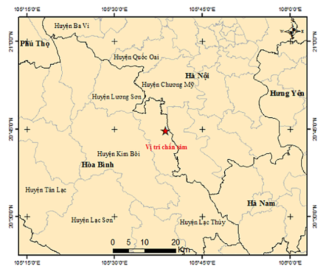
Map of earthquake epicenters in Hoa Binh province. (Image: igp-vast.vn)
Earlier, on December 24th, two earthquakes were recorded in Kon Tum and Son La.
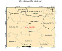
Specifically, at 5:44 AM (Hanoi time), an earthquake with a magnitude of 2.7 on the Richter scale and a focal depth of approximately 7 km occurred in the Muong La district (Son La province).
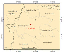
Another earthquake was recorded at 7:27 AM (Hanoi time) in the Kon Plông district, Kon Tum province. The earthquake had a magnitude of 3.0 on the Richter scale and a focal depth of approximately 8 km.
The two earthquakes were flagged as a level 0 natural disaster risk by the Earthquake Information and Tsunami Warning Center - Institute of Geophysics.