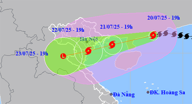
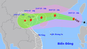
According to the National Center for Meteorological and Hydrological Forecasting, over the past 3 hours, Typhoon Wipha (Typhoon No. 3) has weakened by one level, currently at level 11. Upon entering the Gulf of Tonkin, the typhoon is likely to strengthen again.
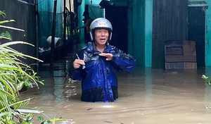
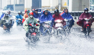
Weather forecast for July 21st: Due to the impact of typhoon Wipha (Typhoon No. 3), Northern Vietnam and North Central Vietnam will experience heavy to very heavy rainfall, with a risk of flooding.
On July 20th, the border guard force of Quang Ninh province issued a notice urging ships and boats to quickly seek safe shelter before typhoon number 3 (Wipha) makes landfall.
Quang Ninh provincial leaders have spoken out after reports emerged that victims were only rescued after three hours following the boat capsizing incident in Ha Long Bay on the afternoon of July 19th.
According to the National Center for Meteorological and Hydrological Forecasting, Typhoon Wipha (Typhoon No. 3) has strengthened by two levels in the past 20 hours, reaching level 12 - the first level of a very strong typhoon (levels 12-15).
Many relatives stayed overnight at the funeral home of Bai Chay Hospital (Quang Ninh) to receive the bodies of the victims of the boat capsizing in Ha Long Bay.
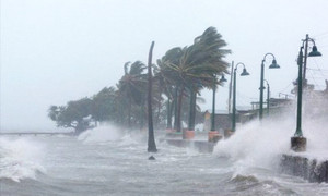
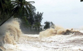
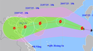
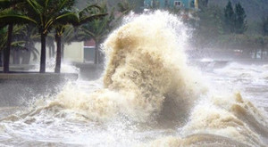
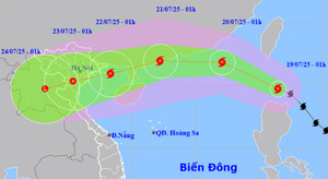
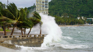
Tonight, Typhoon Wipha continues to strengthen, reaching level 14 and rapidly moving towards the Gulf of Tonkin and the northern part of the South China Sea, with water levels reaching 5-7 meters and extremely rough seas.
The Hai Phong City Party Committee has directed communes, wards, and special zones to develop plans for evacuating residents if necessary, ensuring absolute safety of people and property, including tourists.
The Prime Minister requested that all measures be taken and all forces and resources operating near the area where the ship was in distress be mobilized to urgently conduct search and rescue operations as quickly and effectively as possible.
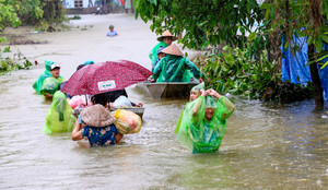
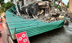
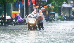
On the afternoon of July 19th, Hanoi experienced a severe thunderstorm that caused the corrugated iron roofing at the Shark Fin construction site to collapse, many trees toppled, and some streets to be partially flooded.
Meteorological experts explain the phenomenon of strong thunderstorms accompanied by lightning that occurred in Hanoi, Quang Ninh, and a number of northern provinces on the afternoon of July 19th.
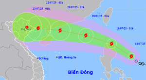
Typhoon No. 3 could reach level 12 intensity while in the eastern part of the Leizhou Peninsula (China), weakening to level 8-10 after entering the Gulf of Tonkin and making landfall in Northern Vietnam, extending to Thanh Hoa province.
To respond to Typhoon No. 3, the Prime Minister directed a review and preparation of evacuation plans for households in dangerous areas; and the development of plans to provide temporary housing and food for the people.
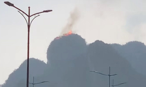
During a thunderstorm on the afternoon of July 19th, lightning struck a mountain peak in Ha Long Bay, Quang Ninh province, causing a fire at the summit.
On the afternoon of July 19th, Hanoi experienced a torrential downpour accompanied by strong gusts of wind, and the sky turned pitch black in broad daylight, causing panic among many people on the streets.
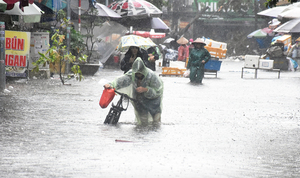
Forecasts indicate that early next week, Northern Vietnam, Thanh Hoa, and Nghe An will experience heavy to very heavy rainfall, with some areas receiving over 600mm. Be prepared for intense downpours.
According to meteorological agencies, Typhoon No. 3 is moving rapidly, has a wide circulation, and could reach level 12 with gusts up to level 15 within the next 24-36 hours.
Typhoon Wipha, with winds reaching level 9 and gusts up to level 12, has made landfall in the South China Sea, becoming the third typhoon of 2025. It is forecast to continue strengthening and reach its peak intensity of level 11-12.
Latest news on Typhoon Wipha today. The typhoon will enter the South China Sea, becoming typhoon number 3, and is forecast to enter the Gulf of Tonkin with a strong intensity of level 9-10, gusting to level 13.
Latest news on Typhoon Wipha: The typhoon is moving rapidly and is forecast to enter the South China Sea tomorrow, July 19th, becoming the third typhoon of the year, causing very heavy rain in Northern Vietnam and Thanh Hoa.
The Deputy Minister of Agriculture and Environment predicted that Typhoon Wipha could bring widespread rain to 18 provinces and 1.713 communes and wards from Ha Tinh northward in the North.
Forecasts indicate that from now until July 21st, Typhoon Wipha will continue to strengthen, potentially reaching levels 11-12, with gusts up to level 15, and is highly likely to directly affect the mainland of Vietnam.
Forecasts indicate that in the early morning of July 19th, Typhoon Wipha will enter the East Sea, becoming the third typhoon of the year, causing very heavy rain in the North and provinces from Thanh Hoa to Ha Tinh.
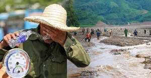
Weather forecast for July 18th: The North will experience hot weather, with some areas experiencing intense heat and maximum temperatures exceeding 37°C, before a period of widespread heavy rain.
This weekend, the East Sea will be hit by typhoon number 3, and the North is likely to experience widespread heavy rain, posing a risk of flash floods and landslides in mountainous areas.
This weekend, the South China Sea is likely to experience the third typhoon of 2025, with a 50-60% probability of moving into the Gulf of Tonkin, posing a risk of heavy rainfall for northern provinces and cities.
The Central Relief Campaign Committee and local relief campaign committees at all levels received 5.303,448 billion VND in donations to support people affected by Typhoon Yagi.
2024 was a year of record-breaking natural disasters, with the North experiencing the strongest typhoon in 30 years, and the Southeast region recording several record-breaking temperatures.
The Central Relief Campaign Committee announces that it will stop accepting donations for people affected by Typhoon No. 3 (Yagi) after 24:12 on December 8th.