Early this morning, Typhoon No. 4 Co May made landfall on the western side of Luzon Island (Philippines). Northern and central Vietnam are about to experience widespread hot weather, ending the period of heavy rain and flooding.
The meteorological agency has issued the latest bulletin on the path and affected area of Typhoon No. 4, Co May, causing bad weather in the eastern part of the North East Sea.
Typhoon No. 4 was one of 10 names proposed by Vietnam for inclusion in the regional typhoon list; this typhoon had virtually no impact on the mainland or coastal areas of our country.
According to the National Center for Meteorological and Hydrological Forecasting, the 2025 typhoon season in the Northwest Pacific region has become very "lively" with three typhoons active simultaneously.
According to the 10-day weather forecast, after a series of heavy rains causing flash floods and landslides in many areas, hot weather is likely to appear in the North and Central regions.
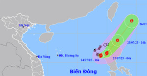
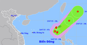
The tropical depression has strengthened into Typhoon No. 4 (international name Comay) in the northern South China Sea; the likelihood of this typhoon directly affecting the mainland of Vietnam is very low.
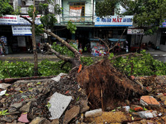
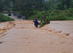
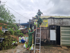
According to reports from local authorities, Typhoon No. 4 and the accompanying floods caused 3 deaths; 261 houses were damaged or had their roofs blown off; and some areas of rice paddies, crops, and aquaculture farms were flooded and damaged.
The Chairman of Hoa Binh province requested Lac Son and Da Bac districts to continue implementing emergency measures and prepare manpower and resources to respond to and mitigate the consequences of natural disasters.
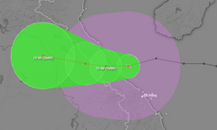
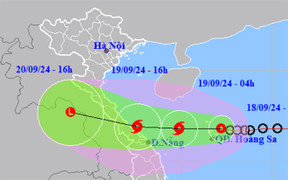
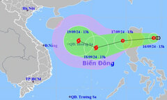
According to the National Center for Hydro-Meteorological Forecasting this afternoon, Typhoon No. 4 made landfall in Quang Binh - Quang Tri provinces and weakened into a tropical depression.
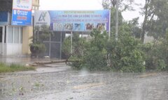
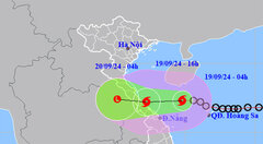
At approximately 4 PM on September 19th, Typhoon No. 4 made landfall in the provinces of Quang Binh and Quang Tri, with maximum wind speeds near the center of the storm reaching level 8, gusting to levels 10-11.
Heavy rain is falling in areas from Ha Tinh to Quang Nam, with the heaviest rainfall in Quang Tri and Thua Thien - Hue, two provinces that have planned to evacuate nearly 30.000 people.
On the morning of September 19th, the tropical depression intensified into typhoon number 4, bringing heavy to very heavy rain to many provinces in the Central region starting today.
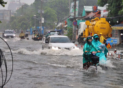
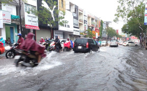
Weather forecast for Ho Chi Minh City today, September 19th: intermittent sunshine, cloudy skies, with showers and thunderstorms in many areas in the afternoon, scattered moderate rain, and heavy rain in some places.
Due to the impact of typhoon number 4, central Vietnam is experiencing heavy to very heavy rainfall, and this weather pattern is forecast to continue with rainfall exceeding 500mm in some areas.
Thua Thien - Hue and Quang Tri are the nearest localities that have planned for students to stay home from school to avoid Typhoon No. 4, which is approaching the mainland from Quang Binh to Da Nang.
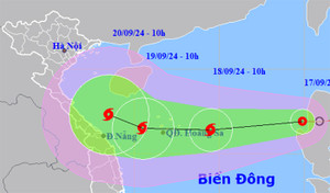
Early this morning (September 19), the tropical depression in the northeastern area of the Hoang Sa archipelago strengthened into a typhoon, the 4th typhoon of 2024.
Do áp thấp nhiệt đới (đang mạnh lên thành bão số 4) diễn biến phức tạp, khó lường nên Ban tổ chức quyết định hoãn Hội chợ thương mại Festival Huế 2024.
Learning from previous storm seasons, people in Central Vietnam took advantage of the opportunity to bring their boats ashore and reinforce their houses very early, in some places even doing this a few days in advance.
This afternoon, the center of the tropical depression is located over the Hoang Sa archipelago, and is forecast to strengthen into typhoon number 4 within the next 12 hours.
According to Deputy Minister Nguyen Hoang Hiep, Typhoon No. 4, which is about to make landfall, could cause heavy rain, and there is a possibility of flooding and flash floods similar to those in 2020 in the central provinces.
Preschool children, students, and trainees throughout Da Nang City will have the afternoon of September 18th and all day September 19th off to prepare for the tropical depression, which has the potential to strengthen into typhoon number 4.
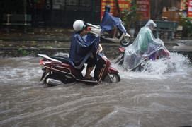
The tropical depression caused heavy rain in central Vietnam, with many houses in Hue and Ha Tinh having their roofs blown off, and Da Nang experiencing severe flooding.
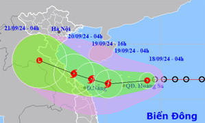
A tropical depression is currently at level 9 on the East Sea, moving rapidly at 25 km/h and is expected to strengthen into a typhoon within the next 24 hours, heading towards the Quang Binh-Da Nang mainland.
The tropical depression has entered the South China Sea, with the potential to strengthen into typhoon number 4 within the next 24 to 48 hours and continuously changing its direction of movement.
On the morning of September 17th, as it entered the South China Sea, the tropical depression tended to strengthen, and by September 18th, it had the potential to intensify into a typhoon, with two possible scenarios.
The meteorological agency forecasts that the tropical depression east of the Philippines will enter the South China Sea, potentially strengthening into typhoon number 4. Hanoi will experience alternating periods of sunshine and rain for the next 10 days.
The Minister of Agriculture and Rural Development requested ministries, sectors, and coastal localities from Quang Ninh to Binh Thuan to monitor the developments of the tropical depression, which may strengthen into a storm.