
Typhoon No. 9 caused damage on the islands in the Spratly archipelago.
Bão số 9 đã đổ bộ và gây ảnh hưởng trực tiếp đến các đảo thuộc quần đảo Trường Sa (huyện Trường Sa, tỉnh Khánh Hòa).
Bão số 9 đã đổ bộ và gây ảnh hưởng trực tiếp đến các đảo thuộc quần đảo Trường Sa (huyện Trường Sa, tỉnh Khánh Hòa).
On the afternoon of October 28th, after several hours of making landfall in provinces from Da Nang to Phu Yen, causing damage to over 1.000 houses with roofs blown off, Typhoon No. 9 weakened into a tropical depression.

Typhoon No. 9, which just swept through Quang Nam and Quang Ngai provinces, destroyed 3 houses and damaged the roofs of 485 houses (including 447 in Quang Ngai).

Deputy Prime Minister Trinh Dinh Dung requested immediate preparation of a plan to use aircraft to rescue the 26 missing crew members at sea when conditions permit.
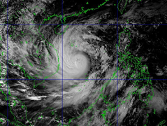
At noon on October 28th, the storm's center was located directly over the coastal areas of provinces and cities from Da Nang to Phu Yen, with the strongest winds near the storm's center reaching level 12, gusting to level 15.

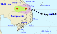
Forecasts indicate that in the next 12 hours, Typhoon No. 9 will make landfall between Da Nang and Phu Yen with maximum wind speeds of level 12-13, gusting to level 15.

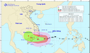
Latest storm update: The center of Typhoon No. 9 is 310km from Phu Yen, with strong winds of level 10-11, near the center of the storm level 12-14, gusts up to level 17; sea waves are 8-10m high; the sea is extremely rough.

Over the next 24 hours, Typhoon No. 9 will make landfall in the provinces from Da Nang to Phu Yen with maximum wind speeds of level 12-13, gusting to level 15.

Forecasts indicate that in the next 24 hours, Typhoon No. 9 will make landfall between Da Nang and Phu Yen with maximum wind speeds of level 12-13, gusting to level 15, before gradually weakening.

The Prime Minister has just signed a directive urgently requesting a response to Typhoon No. 9 - a typhoon predicted to be the strongest in the last 20 years.
On the afternoon of October 27th, Typhoon No. 9 was 390km from Phu Yen, moving in a west-northwest direction and expected to make landfall in the Da Nang - Phu Yen area on the morning of October 28th with wind gusts reaching level 15.
At noon on October 27th, Typhoon No. 9 was approximately 447 km from the provinces from Da Nang to Phu Yen. In the northern and central parts of the East Sea, sea waves reached 8-10 meters in height, resulting in extremely rough seas.

On the morning of October 27th, the Prime Minister directed the establishment of a forward command post in Da Nang to respond to Typhoon No. 9, which is predicted to be the strongest typhoon of the year so far, and is expected to make landfall tomorrow morning.
From the night of October 27th to October 29th, the area from Thua Thien Hue to Phu Yen experienced very heavy rainfall with total rainfall generally ranging from 200-400mm per event.
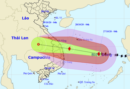
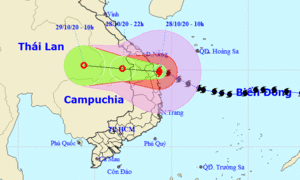
Forecasts indicate that in the next 24 hours, the center of Typhoon No. 9 will be located over the sea off the coast of provinces from Da Nang to Phu Yen, with gusts reaching level 17.
Due to the influence of Typhoon No. 9, from tonight onwards, the southern provinces will experience very heavy rain, with the possibility of thunderstorms, tornadoes, and widespread flooding.
In response to Typhoon No. 9, Khanh Hoa province has urgently organized the evacuation of residents to stay in village cultural centers and school areas.

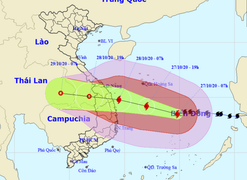
According to the National Center for Meteorological and Hydrological Forecasting, Typhoon No. 9 is shifting southward, causing a change in its center.
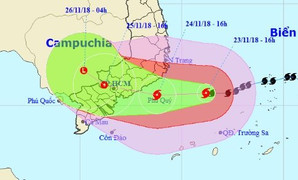
Typhoon No. 9 is now only 300km away from Phu Quy Island, with the strongest winds near the center of the storm reaching level 10 (90-100km/hour), gusting to level 12.

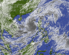
Typhoon No. 9 (Typhoon Usagi) is approaching the mainland of Vietnam with wind speeds of level 6, gusting to level 8, approximately 100km from the storm's center.