Around February 7th, the storm off the coast of the Philippines will enter the South China Sea with the intensity of a tropical depression, becoming the first tropical cyclone in the South China Sea this year.
The December weather forecast predicts severe cold in the North, concentrated in the northern mountainous regions, and the East Sea may experience 1-2 typhoons or tropical depressions.
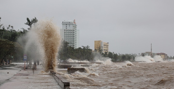
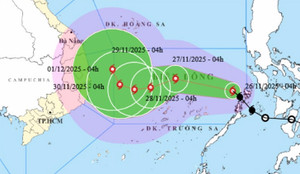
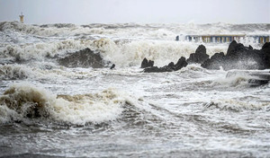
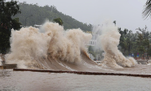
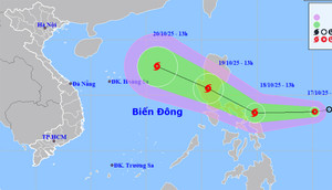
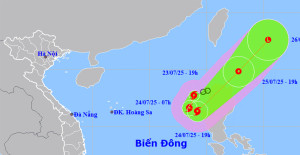
After entering the South China Sea and becoming typhoon number 15, Typhoon Koto slowed down, constantly changing direction, and its maximum intensity could reach level 11, with gusts up to level 14.
Forecasts indicate that the South China Sea is about to be hit by typhoon number 15, and its development after November 27th remains highly unpredictable in terms of both intensity and trajectory.
Forecasts indicate that over the next month, the South China Sea is likely to experience 1-2 typhoons or tropical depressions, and central Vietnam may experience widespread heavy rainfall.
In late November, Typhoon No. 15 may appear in the East Sea, and the area from southern Quang Tri to Da Nang, the eastern part of Quang Ngai province to Dak Lak, and Khanh Hoa province are at risk of renewed heavy rain.
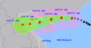
Forecasts indicate that the East Sea is about to be hit by Typhoon No. 13, a powerful storm that will move inland into Vietnam on November 7th, with the area most directly affected being Da Nang to Khanh Hoa.
The tropical depression is forecast to strengthen into a typhoon and enter the South China Sea around the beginning of next week, becoming the 12th typhoon of 2025.
According to the 10-day weather forecast, the North will experience a cold front, with temperatures turning cold at night and in the morning next week, and some mountainous areas experiencing freezing temperatures. Typhoon No. 12 may also hit the East Sea.
According to the October weather forecast, the East Sea is likely to experience 2-3 typhoons and tropical depressions, and the northern and central provinces are likely to experience widespread heavy rainfall.
General Nguyen Tan Cuong stated that the Ministry of National Defense has mobilized 240.580 officers and soldiers along with more than 4.000 vehicles to be ready to respond to Typhoon No. 10.
According to the Deputy Minister of Agriculture and Environment, Typhoon Bualoi (Typhoon No. 10) is moving twice as fast as a normal typhoon, becoming stronger as it approaches the coast, posing a direct threat to the North Central region.
Over the past five years, the South China Sea has typically seen only 4-6 typhoons in the first nine months of the year, but 2025 is expected to see a dramatic increase with 10 typhoons.
Since the beginning of the year, Vietnam has faced a series of storms and tropical depressions such as Ragasa, Mitag, and the upcoming Bualoi. What is causing these storms to occur so frequently?
In response to Typhoon Ragasa, maintaining connectivity via telephone, radio, walkie-talkie, or satellite equipment could determine the survival of you and your family.
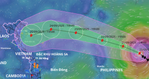
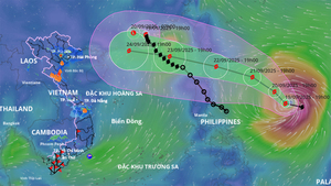
The meteorological agency has released its latest bulletin forecasting the intensity and trajectory of Super Typhoon Ragasa after nearly a day of "raging" in the South China Sea, and predicting the time the typhoon will make landfall in Vietnam.
According to meteorological agencies, Typhoon Ragasa is rapidly intensifying, is expected to become a super typhoon, and will enter the South China Sea on September 23rd.
The meteorological agency predicts that Typhoon Ragasa could become a super typhoon, with gusts exceeding level 17, and is moving into the South China Sea, causing severe sea disturbances and waves over 10 meters high from September 23rd.
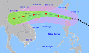
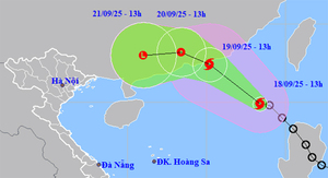
The tropical depression in the East Sea has strengthened into Typhoon Mitag (Typhoon No. 8) with an intensity of level 8, gusting to level 10. Northern Vietnam and North Central Vietnam are about to experience widespread heavy rain.
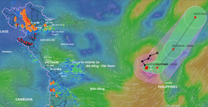
During the last 10 days of September, there is a high probability of 1-2 strong typhoons forming in the waters east of the Philippines, which could enter the South China Sea and affect Vietnam's mainland.
According to the 10-day weather forecast, Hanoi and other northern provinces and cities will experience heavy rain and thunderstorms, and the East Sea is likely to welcome a typhoon, moving into the Gulf of Tonkin in the next 2-3 days.
Forecasts indicate that within the next 24 hours, the low-pressure system is likely to move into the South China Sea and strengthen into a tropical depression, then further intensify into a typhoon, bringing heavy rain to the northern region.
Typhoon No. 4 was one of 10 names proposed by Vietnam for inclusion in the regional typhoon list; this typhoon had virtually no impact on the mainland or coastal areas of our country.
The tropical depression has strengthened into Typhoon No. 4 (international name Comay) in the northern South China Sea; the likelihood of this typhoon directly affecting the mainland of Vietnam is very low.
The Pa Thơm suspension bridge (Thanh Yên commune, Điện Biên province) suffered a cable break, causing a pickup truck carrying commune officials on a storm preparedness inspection and a motorbike to fall into the river.
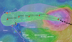
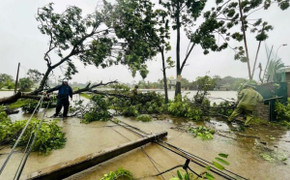
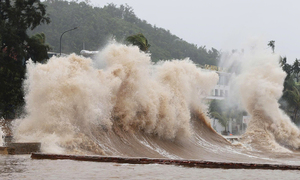
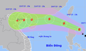
Early this morning, Typhoon Wipha (Typhoon No. 3) reached level 14 and headed towards the northern mainland and Thanh Hoa province, causing heavy rain in the area with rainfall exceeding 600mm in some places.
The Deputy Minister of Agriculture and Environment predicted that Typhoon Wipha could bring widespread rain to 18 provinces and 1.713 communes and wards from Ha Tinh northward in the North.
The path and impact of Typhoon Wipha, which resembles Yagi, is forecast to affect the mainland of Vietnam from evening to night on July 21st, causing heavy rain in the northern and central regions.