The meteorological and hydrological agency predicts that the tropical depression, after entering the East Sea, could strengthen into typhoon number 15, heading towards the South Central coastal region.
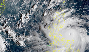
In the early afternoon of August 29th, Typhoon Saola, with gusts reaching level 17, was located in the waters northeast of Luzon Island (Philippines), and was forecast to enter the South China Sea within the next 48 hours.
On the morning of July 26th, the center of Typhoon Doksuri was located in the sea north of Luzon Island, with maximum sustained winds near the center reaching levels 15-16, gusting above level 17 before entering the South China Sea.
Between July 15th and 20th, there is a possibility of disturbances forming in the tropical convergence zone and developing into tropical depressions/storms over the South China Sea.
Meteorological experts predict that on October 30th, Typhoon Nalgae will cross central Philippines and enter the South China Sea, with its trajectory still subject to change.
The meteorological agency forecasts that around the afternoon and night of September 27th, Typhoon No. 4 will affect the mainland, with a scenario of heavy rainfall exceeding 400mm, putting approximately 60 districts and urban areas at risk of flooding.
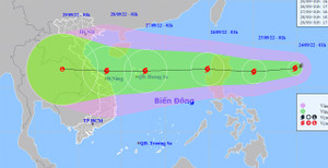
In response to Typhoon Noru, which is approaching the South China Sea and is expected to become the fourth typhoon of 2022, the Prime Minister has requested relevant localities to postpone non-urgent meetings.
According to the Director General of the National Meteorological and Hydrological Service, Typhoon Noru is predicted to be one of the strongest typhoons in the past 20 years.
On the afternoon of September 25th, Typhoon Noru is expected to make landfall in the Philippines. This is a very strong typhoon, moving rapidly, and could cause heavy rain after making landfall in central Vietnam.
Typhoon Noru is continuously strengthening before entering the South China Sea and is forecast to make landfall in central Vietnam. Heavy rain in this area will continue today, September 25th.
Typhoon Noru, with wind gusts reaching level 11, is located approximately 810km east of Luzon Island (Philippines) and is expected to enter the South China Sea within the next 24 to 48 hours, gradually intensifying.
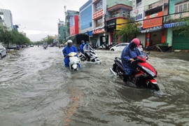
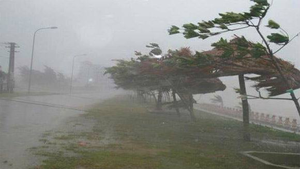
Tonight, the central region is forecast to enter the peak of this rainfall period, with common rainfall amounts of 200-350mm, and some areas exceeding 450mm. Flash floods and landslides should be anticipated.
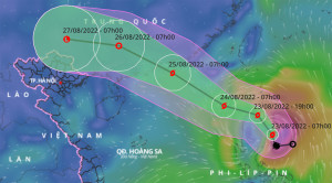
At 4:8 AM today (August 24th), the strongest winds near the center of Typhoon No. 3 reached level 10 (89-102 km/hour), with gusts up to level 13, and sea waves reaching 6-8 meters in height; the sea was extremely rough.
According to today's weather forecast (August 23), the eastern part of the North East Sea will experience increasingly strong winds, reaching levels 6-7, with winds near the storm's center reaching level 9, gusting to level 12, and rough seas.
From April 7-8, there is a possibility of one tropical depression forming in the southern part of the South China Sea and two storms east of the Philippines, which may enter the South China Sea.
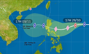
Typhoon Rai, with winds reaching level 10 and gusts up to level 12 off the coast of the Philippines, is continuing to move in a west-northwest direction. On December 19-20, the typhoon will directly affect the mainland.
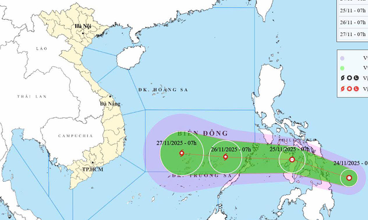
A low-pressure system currently active over the sea east of southern Philippines has the potential to strengthen into a typhoon within the next 2-3 days.
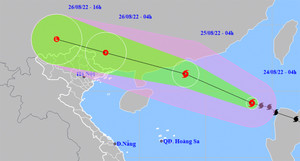
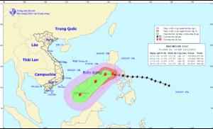
Provinces and cities from Thanh Hoa to Khanh Hoa need to closely monitor developments and prepare forces and resources to respond to Typhoon Goni, which is about to enter the East Sea.
After sweeping across central Philippines, Super Typhoon Goni will weaken and enter the South China Sea with wind speeds of level 10-11 (90-115 km/h), gusting to level 13.
Given the unpredictable developments and wide-ranging impact of Super Typhoon Mangkhut, 27 provinces and cities are urgently implementing response measures to ensure the safety of their citizens.
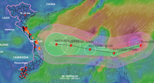
Following reports that Typhoon No. 13 was intensifying and heading straight towards central Vietnam, Thua Thien-Hue province requested that hydroelectric dams accelerate floodwater release starting from the afternoon of November 10th.
Tropical storm Matthew, after sweeping through the Caribbean, killed hundreds of people, with casualties mostly in Haiti. Four US states declared states of emergency in preparation for the storm.