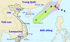
Typhoon No. 13 is forecast to enter the East Sea on the morning of November 12th, sharing many characteristics with Typhoon No. 9 and potentially causing severe damage to central Vietnam.
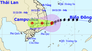
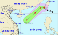
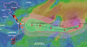
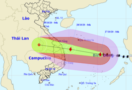
This morning, the center of Typhoon No. 12, with winds reaching level 9 and gusts up to level 12, is located over the sea area from Binh Dinh to Ninh Thuan, and will move inland within the next 12 hours.
Typhoon No. 12, with gusts reaching level 11, is currently about 290km from the coast of provinces from Binh Dinh to Ninh Thuan, and is forecast to make landfall in these provinces tomorrow.
According to Mr. Mai Van Khiem, Director of the National Center for Meteorological and Hydrological Forecasting, another tropical depression is expected to enter the East Sea on the night of November 11th and the morning of November 12th, with the potential to develop into a typhoon.
Due to the circulation of typhoon No. 12 combined with a cold front, from this afternoon (November 9th) until November 12th, provinces from Quang Tri to Khanh Hoa will experience heavy to very heavy rain.
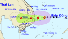
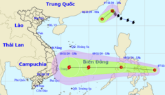
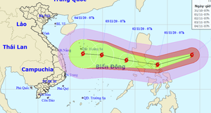
The tropical depression in the East Sea has strengthened into Typhoon No. 12 with wind gusts of level 10, bringing heavy to very heavy rain to provinces from Quang Tri to Khanh Hoa starting this afternoon.
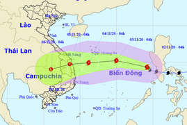
The tropical depression in the East Sea has the potential to strengthen into a storm with gusts reaching level 11, located approximately 330km off the coast of provinces from Phu Yen to Ninh Thuan.
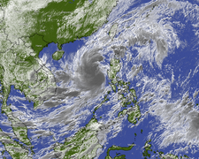
The tropical depression currently off the central coast of the Philippines has the potential to strengthen into Typhoon No. 12 with wind gusts reaching level 10 when it enters the South China Sea.
This afternoon, Typhoon No. 11 weakened into a tropical depression; however, a tropical depression is active in the waters east of the Philippines and is about to enter the South China Sea.
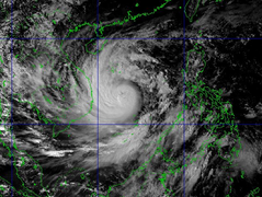
On the evening of November 6th, Typhoon No. 11 (international name Atsani) entered the South China Sea with maximum sustained winds near the center reaching level 9 (75-90 km/h), with gusts up to level 11.
Last night, Typhoon Goni entered the South China Sea with wind speeds of level 9, gusting to level 12, becoming the 10th typhoon to affect our country.
After sweeping across central Philippines, Super Typhoon Goni will weaken and enter the South China Sea with wind speeds of level 10-11 (90-115 km/h), gusting to level 13.
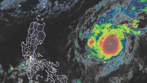
Super Typhoon Goni, currently located about 360km from central Philippines, is still experiencing strong winds of level 17 (200-220 km/h), with gusts exceeding level 17, and will weaken as it enters the South China Sea.
Super typhoon Goni, with wind speeds of level 17 (200-220 km/h) and gusts exceeding level 17, is approaching the Philippines and will then enter the South China Sea.
From now until October 31st, the central provinces will continue to experience heavy to very heavy rainfall, and the risk of flooding, flash floods, and landslides remains high in many areas.
A new storm has just formed east of the Philippines, and it is likely to strengthen and move into the South China Sea, bringing heavy rain to central Vietnam next weekend.
Typhoon No. 9, which just swept through Quang Nam and Quang Ngai provinces, destroyed 3 houses and damaged the roofs of 485 houses (including 447 in Quang Ngai).
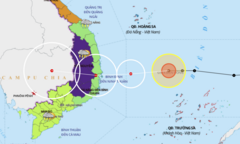
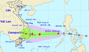
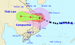
At noon on October 28th, the storm's center was located directly over the coastal areas of provinces and cities from Da Nang to Phu Yen, with the strongest winds near the storm's center reaching level 12, gusting to level 15.
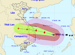
Forecasts indicate that in the next 12 hours, Typhoon No. 9 will make landfall between Da Nang and Phu Yen with maximum wind speeds of level 12-13, gusting to level 15.
Forecasts indicate that in the next 24 hours, Typhoon No. 9 will make landfall between Da Nang and Phu Yen with maximum wind speeds of level 12-13, gusting to level 15, before gradually weakening.
The Prime Minister has just signed a directive urgently requesting a response to Typhoon No. 9 - a typhoon predicted to be the strongest in the last 20 years.
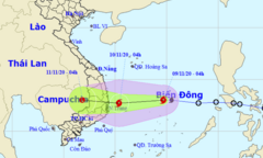
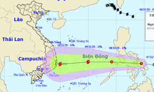
On the afternoon of October 27th, Typhoon No. 9 was 390km from Phu Yen, moving in a west-northwest direction and expected to make landfall in the Da Nang - Phu Yen area on the morning of October 28th with wind gusts reaching level 15.
At noon on October 27th, Typhoon No. 9 was approximately 447 km from the provinces from Da Nang to Phu Yen. In the northern and central parts of the East Sea, sea waves reached 8-10 meters in height, resulting in extremely rough seas.
On the morning of October 27th, the Prime Minister directed the establishment of a forward command post in Da Nang to respond to Typhoon No. 9, which is predicted to be the strongest typhoon of the year so far, and is expected to make landfall tomorrow morning.
From the night of October 27th to October 29th, the area from Thua Thien Hue to Phu Yen experienced very heavy rainfall with total rainfall generally ranging from 200-400mm per event.
Forecasts indicate that in the next 24 hours, the center of Typhoon No. 9 will be located over the sea off the coast of provinces from Da Nang to Phu Yen, with gusts reaching level 17.