Forecasts indicate that in the next 3 hours, Typhoon Wipha (Typhoon No. 3) will bring heavy rain to Thanh Hoa and Nghe An provinces, with many areas at high risk of flash floods and landslides.
Typhoon No. 3 is about 10km from Hung Yen, 25km from Ninh Binh, and is about to make landfall. Heavy rain is forecast to continue in the North until the end of the week.
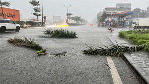
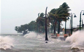
Heavy rains caused by Typhoon No. 3 have resulted in severe flooding in many streets in Sam Son, Thanh Hoa, paralyzing traffic, closing shops, and leaving the streets deserted.
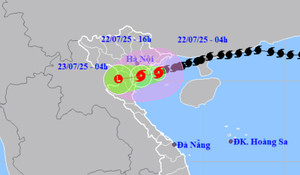
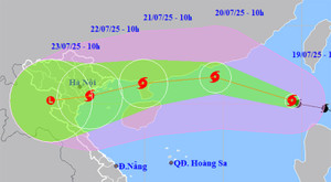
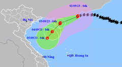
Typhoon Wipha (Typhoon No. 3) has approached the Vietnamese mainland. Experts have offered their assessments regarding the timing and intensity of the typhoon's landfall in Hai Phong and Ninh Binh.
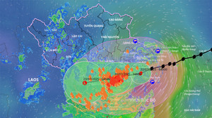
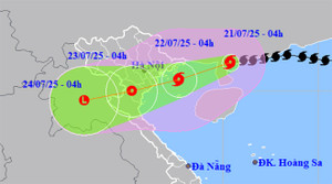
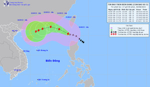
Forecast for 10-14h today: Typhoon Wipha (Typhoon No. 3) will make landfall south of Hai Phong - Ninh Binh, with intensity level 8-9, gusts level 11-12, bringing continued heavy to very heavy rain to Northern and North Central Vietnam.
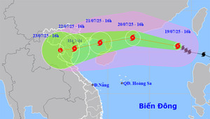
Forecasts indicate that around noon to afternoon tomorrow, July 22nd, the center of Typhoon Wipha (Typhoon No. 3) will move inland into the provinces from Hai Phong to northern Thanh Hoa.
Forecasts indicate that when the center of typhoon Wipha (Typhoon No. 3) is over the sea area from Hai Phong to Thanh Hoa, it will maintain winds of level 10-11, potentially causing ships to sink, trees toppled, power poles to fall, and roofs to be ripped off...
Given the complex developments of Typhoon No. 3, Hanoi police are intensifying inspections along the Red River, assisting residents in anchoring boats, reinforcing floating houses, and preparing evacuation plans.
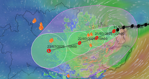
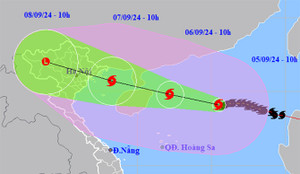
Typhoon No. 3 has intensified again after entering the Gulf of Tonkin, with forecasts predicting increased rainfall from this evening and peaking from tonight to tomorrow morning as the storm's center approaches the Vietnamese coast.
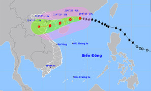
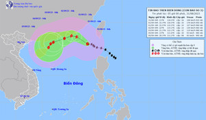
Typhoon Wipha (Typhoon No. 3) reached level 11 and entered the Gulf of Tonkin, approximately 190km from Quang Ninh at 10:00 AM. The typhoon is expected to intensify in the next 24 hours, causing heavy rain and flooding in Northern and North Central Vietnam.
Typhoon No. 3 is currently at level 9, with gusts up to level 12, located 233km from Hai Phong-Quang Ninh, and may intensify in the next 24 hours, causing heavy rain in Northern and North Central Vietnam.
Quang Ninh provincial leaders have spoken out after reports emerged that victims were only rescued after three hours following the boat capsizing incident in Ha Long Bay on the afternoon of July 19th.
Typhoon Wipha (Typhoon No. 3) has reached level 12 and is forecast to enter the eastern part of the Gulf of Tonkin tomorrow, July 21st, causing heavy rain in Northern and North Central Vietnam.
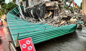
On the afternoon of July 19th, Hanoi experienced a severe thunderstorm that caused the corrugated iron roofing at the Shark Fin construction site to collapse, many trees toppled, and some streets to be partially flooded.
Typhoon No. 3 could reach level 12 intensity while in the eastern part of the Leizhou Peninsula (China), weakening to level 8-10 after entering the Gulf of Tonkin and making landfall in Northern Vietnam, extending to Thanh Hoa province.
According to meteorological agencies, Typhoon No. 3 is moving rapidly, has a wide circulation, and could reach level 12 with gusts up to level 15 within the next 24-36 hours.
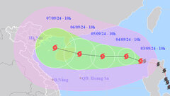
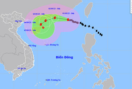
Latest news on Typhoon Wipha: The typhoon is moving rapidly and is forecast to enter the South China Sea tomorrow, July 19th, becoming the third typhoon of the year, causing very heavy rain in Northern Vietnam and Thanh Hoa.
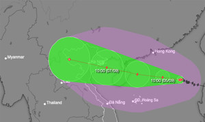
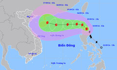
Yagi is maintaining its super typhoon status and rapidly moving into the Gulf of Tonkin, forecast to make landfall in the provinces of Quang Ninh and Thai Binh, bringing strong winds, high waves, and heavy rain.
Typhoon No. 3 has intensified into a super typhoon, rapidly approaching the Gulf of Tonkin and causing strong winds and high waves at sea. From tomorrow night, Northern Vietnam and North Central Vietnam are likely to experience very heavy rainfall.
This morning, Typhoon No. 3 (Yagi) continued to intensify and head towards the Gulf of Tonkin. Strong winds are forecast to reach level 15 near the storm's center, causing extremely rough seas.
Forecasts indicate that in the coming days, Typhoon No. 3 could reach level 13, with gusts up to level 16 near the storm's center, and is likely to enter the Gulf of Tonkin and affect the mainland of Vietnam.
Forecasts indicate that this afternoon and tonight, Typhoon Yagi will enter the South China Sea, becoming the third typhoon of 2024. The typhoon is likely to reach very strong typhoon status within the next 1-3 days.
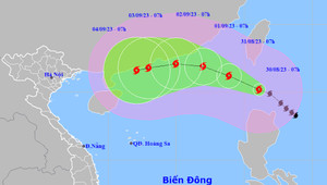
Early this morning, September 2nd, the center of Typhoon No. 3 was located in the sea southwest of Guangdong province, China; the strongest winds near the center of the typhoon reached levels 12-13.
Typhoon No. 3 continuously changed direction. At 4 PM on September 1st, the strongest winds near the center of the typhoon reached levels 14-15 (150-183 km/h), with gusts exceeding level 17.
Bão số 3 giật trên cấp 17 ở Biển Đông, cách Hong Kong (Trung Quốc) khoảng 280 km về phía Đông Đông Nam, vùng gần tâm bão sóng biển có thể lên tới 8-10 m.
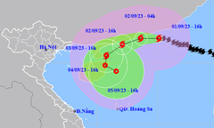
In the early afternoon of August 31st, the strongest winds near the center of Typhoon No. 3 reached levels 15-16, with gusts exceeding level 17, causing extremely rough seas.
Early this morning, August 31st, Typhoon No. 3 (Typhoon Saola), with a strength of level 16 - a super typhoon, was located approximately 510 km southeast of Hong Kong (China).