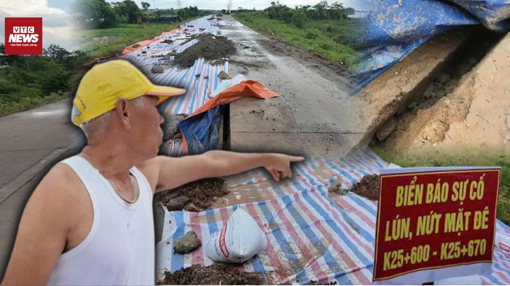
Key dike in Hanoi cracks, traffic banned.
A section of the right embankment of Cau Bridge in Da Phuc commune, Hanoi, has cracked and subsided severely, prompting local authorities to cordon off the area and prohibit vehicle traffic.
A section of the right embankment of Cau Bridge in Da Phuc commune, Hanoi, has cracked and subsided severely, prompting local authorities to cordon off the area and prohibit vehicle traffic.
On the evening of July 22nd, Typhoon Wipha (Typhoon No. 3) weakened into a tropical depression, bringing torrential rain to a series of provinces in Northern and North Central Vietnam, with a high risk of flash floods and landslides in many areas.
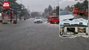
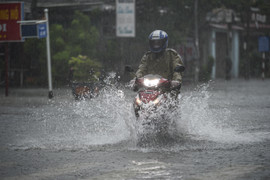
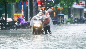
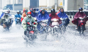
In many sections of Le Loi Avenue, the water level rose 20-40 cm, causing numerous cars to break down and forcing many vehicles to turn around and find alternative routes.
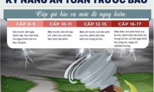
During a storm, people should not seek shelter under trees, power poles, or other easily falling objects; they should be wary of accidents caused by collapsing houses, trees, power poles, objects blown away by the wind, and electric shocks.
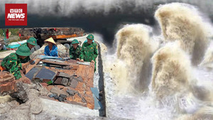
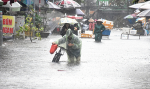
Heavy rains caused by Typhoon No. 3 have resulted in severe flooding in many streets in Sam Son, Thanh Hoa, paralyzing traffic, closing shops, and leaving the streets deserted.

A 300-meter-long crack has appeared on Pha Mat Mountain (Nghe An province), forcing authorities to urgently relocate 19 households in the dangerous area to safety before typhoon No. 3 makes landfall.

The Ministry of Agriculture and Environment has requested local authorities to take coercive measures to bring boats and ships ashore to anchor and avoid Typhoon Wipha (Typhoon No. 3).
Given the urgent situation caused by Typhoon Wipha, the Hai Phong authorities are focusing their efforts on implementing drastic preventative measures.

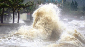
Forecasts indicate that when the center of typhoon Wipha (Typhoon No. 3) is over the sea area from Hai Phong to Thanh Hoa, it will maintain winds of level 10-11, potentially causing ships to sink, trees toppled, power poles to fall, and roofs to be ripped off...
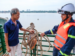
Given the complex developments of Typhoon No. 3, Hanoi police are intensifying inspections along the Red River, assisting residents in anchoring boats, reinforcing floating houses, and preparing evacuation plans.

It's biased to ask questions like "why did they go even knowing there was a storm?", "why didn't they wear life jackets?"; the data proves that the victims of the Green Bay 58 boat capsizing did nothing wrong.
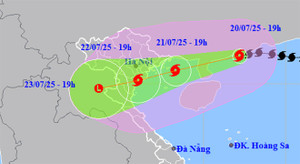
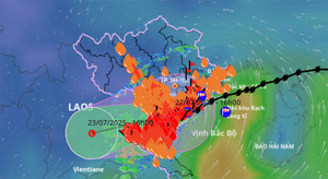
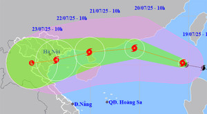
According to the National Center for Meteorological and Hydrological Forecasting, over the past 3 hours, Typhoon Wipha (Typhoon No. 3) has weakened by one level, currently at level 11. Upon entering the Gulf of Tonkin, the typhoon is likely to strengthen again.

Quang Ninh provincial leaders have spoken out after reports emerged that victims were only rescued after three hours following the boat capsizing incident in Ha Long Bay on the afternoon of July 19th.
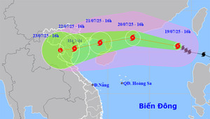
Typhoon Wipha (Typhoon No. 3) has reached level 12 and is forecast to enter the eastern part of the Gulf of Tonkin tomorrow, July 21st, causing heavy rain in Northern and North Central Vietnam.
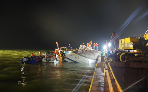
A representative from the Quang Ninh Provincial People's Committee stated that rescue helicopters were not used because the scene was close to the shore, there were no designated landing points, and bad weather could easily create dangerous conditions.
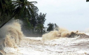
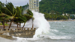
Tonight, Typhoon Wipha continues to strengthen, reaching level 14 and rapidly moving towards the Gulf of Tonkin and the northern part of the South China Sea, with water levels reaching 5-7 meters and extremely rough seas.
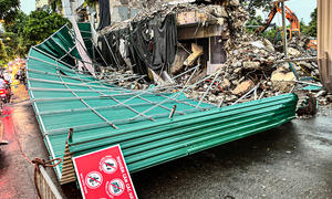
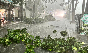
On the afternoon of July 19th, Hanoi experienced a severe thunderstorm that caused the corrugated iron roofing at the Shark Fin construction site to collapse, many trees toppled, and some streets to be partially flooded.
Meteorological experts explain the phenomenon of strong thunderstorms accompanied by lightning that occurred in Hanoi, Quang Ninh, and a number of northern provinces on the afternoon of July 19th.
Typhoon No. 3 could reach level 12 intensity while in the eastern part of the Leizhou Peninsula (China), weakening to level 8-10 after entering the Gulf of Tonkin and making landfall in Northern Vietnam, extending to Thanh Hoa province.

On the afternoon of July 19th, Hanoi experienced a torrential downpour accompanied by strong gusts of wind, and the sky turned pitch black in broad daylight, causing panic among many people on the streets.
According to meteorological agencies, Typhoon No. 3 is moving rapidly, has a wide circulation, and could reach level 12 with gusts up to level 15 within the next 24-36 hours.
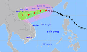
Typhoon Wipha, with winds reaching level 9 and gusts up to level 12, has made landfall in the South China Sea, becoming the third typhoon of 2025. It is forecast to continue strengthening and reach its peak intensity of level 11-12.
Latest news on Typhoon Wipha today. The typhoon will enter the South China Sea, becoming typhoon number 3, and is forecast to enter the Gulf of Tonkin with a strong intensity of level 9-10, gusting to level 13.
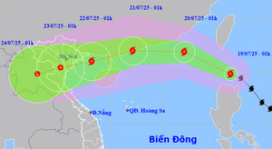
Latest news on Typhoon Wipha: The typhoon is moving rapidly and is forecast to enter the South China Sea tomorrow, July 19th, becoming the third typhoon of the year, causing very heavy rain in Northern Vietnam and Thanh Hoa.
Forecasts indicate that from now until July 21st, Typhoon Wipha will continue to strengthen, potentially reaching levels 11-12, with gusts up to level 15, and is highly likely to directly affect the mainland of Vietnam.
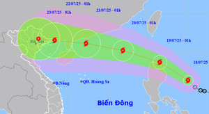
Forecasts indicate that in the early morning of July 19th, Typhoon Wipha will enter the East Sea, becoming the third typhoon of the year, causing very heavy rain in the North and provinces from Thanh Hoa to Ha Tinh.

Weather forecast for July 18th: The North will experience hot weather, with some areas experiencing intense heat and maximum temperatures exceeding 37°C, before a period of widespread heavy rain.
This weekend, the East Sea will be hit by typhoon number 3, and the North is likely to experience widespread heavy rain, posing a risk of flash floods and landslides in mountainous areas.
This weekend, the South China Sea is likely to experience the third typhoon of 2025, with a 50-60% probability of moving into the Gulf of Tonkin, posing a risk of heavy rainfall for northern provinces and cities.

Thousands of hectares of crops, plants, and livestock farms belonging to cooperatives were damaged by Typhoon No. 3 (Typhoon Yagi).