Early this morning, Typhoon No. 4 Co May made landfall on the western side of Luzon Island (Philippines). Northern and central Vietnam are about to experience widespread hot weather, ending the period of heavy rain and flooding.
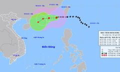
The meteorological agency has issued the latest bulletin on the path and affected area of Typhoon No. 4, Co May, causing bad weather in the eastern part of the North East Sea.
Typhoon No. 4 was one of 10 names proposed by Vietnam for inclusion in the regional typhoon list; this typhoon had virtually no impact on the mainland or coastal areas of our country.
According to the National Center for Meteorological and Hydrological Forecasting, the 2025 typhoon season in the Northwest Pacific region has become very "lively" with three typhoons active simultaneously.
According to the 10-day weather forecast, after a series of heavy rains causing flash floods and landslides in many areas, hot weather is likely to appear in the North and Central regions.
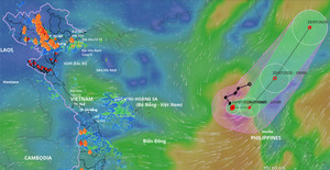
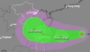
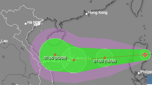
The tropical depression has strengthened into Typhoon No. 4 (international name Comay) in the northern South China Sea; the likelihood of this typhoon directly affecting the mainland of Vietnam is very low.
After forming for over 4 hours, the tropical depression entered the South China Sea and intensified to level 6-7, with gusts up to level 8. It is forecast to strengthen into a typhoon tomorrow.
Following Typhoon No. 4, tens of tons of trash accumulated on the Han River and beaches in Da Nang, prompting authorities to mobilize approximately 100 workers and machinery for cleanup.
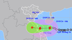
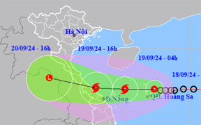
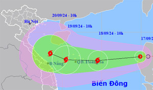
According to the National Center for Hydro-Meteorological Forecasting, at 10:9 AM on September 19th, the center of Typhoon No. 4 (Soulik) was located in the coastal waters from Quang Binh to Thua Thien Hue.
On the evening of September 19th, authorities in Quang Tri province organized the emergency relocation of 84 households in areas at risk of landslides due to heavy rain.
According to the National Center for Hydro-Meteorological Forecasting this afternoon, Typhoon No. 4 made landfall in Quang Binh - Quang Tri provinces and weakened into a tropical depression.
At approximately 4 PM on September 19th, Typhoon No. 4 made landfall in the provinces of Quang Binh and Quang Tri, with maximum wind speeds near the center of the storm reaching level 8, gusting to levels 10-11.
On the night of September 18th, the authorities of Nam Tra My district (Quang Nam province) carried out an emergency evacuation of 51 households with 164 people in residential areas at high risk of landslides.
Weather forecast for Ho Chi Minh City today, September 19th: intermittent sunshine, cloudy skies, with showers and thunderstorms in many areas in the afternoon, scattered moderate rain, and heavy rain in some places.
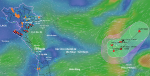
Early this morning (September 19), the tropical depression in the northeastern area of the Hoang Sa archipelago strengthened into a typhoon, the 4th typhoon of 2024.
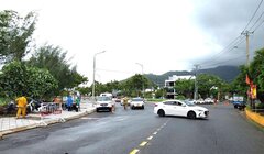
Da Nang has set up checkpoints on Hoang Sa road, preventing people and vehicles from going to Son Tra peninsula to ensure safety amidst the complex developments of the storm.
This afternoon, the center of the tropical depression is located over the Hoang Sa archipelago, and is forecast to strengthen into typhoon number 4 within the next 12 hours.
Quang Ngai province has banned passenger transport on the Sa Ky - Ly Son route and vice versa, while Hoi An has also banned boats from going to Cu Lao Cham island.
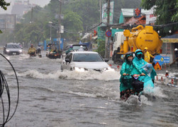
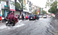
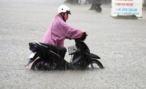
Heavy rain from the night of September 17th to the morning of September 18th caused flooding in many streets in Da Nang, disrupting traffic and forcing parents to wade through water to take their children to school.
From today, September 18th to September 19th, many areas in Central Vietnam will experience torrential rain, with some places receiving over 400mm of rainfall, posing a risk of flooding in low-lying areas.
Today, the whole country will continue to experience thunderstorms, with heavy to very heavy rain concentrated in the northern and central regions of Central Vietnam.
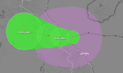
Meteorological and hydrological experts have assessed the path and landfall area of the tropical depression that later strengthened into typhoon number 4.
The tropical depression has entered the South China Sea, with the potential to strengthen into typhoon number 4 within the next 24 to 48 hours and continuously changing its direction of movement.
Forecasts indicate that over the next 24 hours, the tropical depression will move into the South China Sea, strengthen into the fourth typhoon of the year, and head towards the Paracel Islands.
Over the next 10 days, Central Vietnam may experience some severe weather patterns causing heavy rainfall; the rainfall pattern will depend on the intensity of the cold air mass and the location of the tropical convergence zone.
Tonight, October 9th, a verstärkt cold front will affect the Northeast region, then the North Central region and some areas in the Northwest region, bringing cold weather at night and in the morning, with temperatures dropping below 16 degrees Celsius in some places.
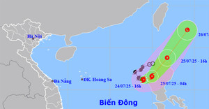
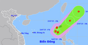
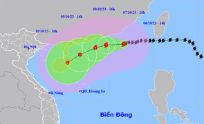
Early this morning, October 7th, Typhoon No. 4 reached level 16 in the East Sea, bringing showers and thunderstorms to northern Vietnam, with moderate rain in mountainous and hilly areas, and heavy to very heavy rain in some places.
Over the past 3 hours, Typhoon No. 4 (international name Koinu) has intensified by one level after moving into the sea southeast of Guangdong province (China).
Early morning on October 6th, Typhoon No. 4 was located in the northeastern part of the South China Sea, then gradually weakened, decreasing by about 2 levels each day, making it unlikely to affect Vietnam.