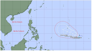
The meteorological agency has released its assessment of the path of Super Typhoon Sinlaku, and also predicted the probability of the super typhoon entering the South China Sea.
The meteorological center forecasts that over the next 24 hours, the tropical depression in the Northwest Pacific will move slowly westward, with the potential to strengthen into a typhoon.
According to the National Center for Hydro-Meteorological Forecasting, the "unusual tropical depression of the year" has dissipated over the sea, and Typhoon No. 15 has weakened to level 9 and is hardly moving.
Immediately after typhoon number 15, forecasting models indicated the possibility of a new typhoon named Wilma forming near the Philippines in early December, with the potential to enter the South China Sea.
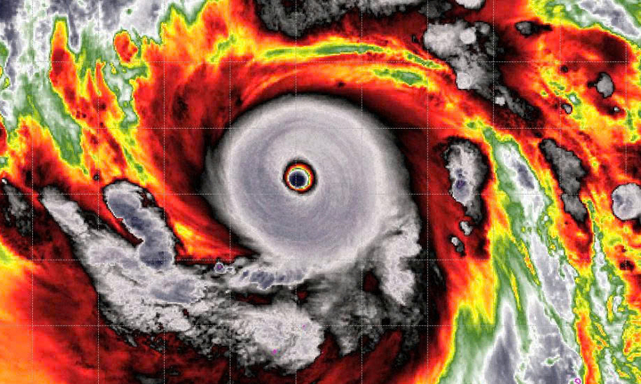
The meteorological agency has issued the latest bulletin on the path and intensity of Typhoon Koto (Typhoon No. 15). The typhoon is currently at level 11, with gusts up to level 14, and is showing a tendency to gradually weaken.
The meteorological agency assessed that Typhoon No. 15 reached its strongest intensity while operating over the East Sea, its speed slowed down, and it continuously changed direction, making its development unpredictable.
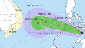
Experts warn that Typhoon Koto (Typhoon No. 15) is moving unusually slowly, only traveling at a speed of about 5-10 km/h since the afternoon of November 28, and its impact is expected to last 5-7 days.
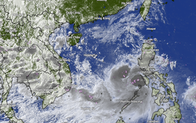
Experts have offered initial assessments of two possible paths for the tropical depression, which is expected to intensify into a storm, putting central Vietnam at risk of widespread heavy rainfall.
Meteorological experts believe Kalmaegi is a very strong typhoon with a wide circulation, and its path and impact are similar to Typhoon Damrey in 2017 and Molave in 2020.
Experts predict that the remnants of Typhoon No. 12 will cause widespread heavy rain, and the Ha Tinh - Quang Ngai area may experience prolonged flooding until the end of October, or even into early November.
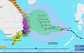
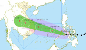
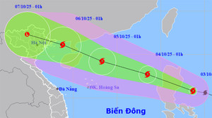
This afternoon (October 3), Typhoon Matmo weakened slightly as it passed through Luzon (Philippines), but is forecast to strengthen again over the South China Sea, causing strong gusts of wind and high waves.
On the morning of October 3rd, Typhoon Matmo was forecast to make landfall in Northern Luzon (Philippines) before entering the South China Sea and potentially intensifying rapidly.
The meteorological agency has issued the latest bulletin on Typhoon Matmo, stating that the storm is moving rapidly and could reach level 12 on the South China Sea, heading towards the Gulf of Tonkin.
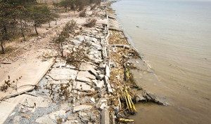
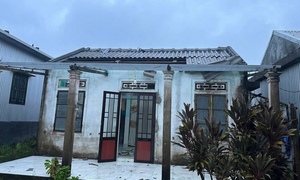
In just minutes, a raging tornado off the coast of Ninh Binh swept away houses, killing 9 people and collapsing hundreds of homes, leaving behind scenes of grief throughout the countryside.
48 delegates from 40 delegations in Lao Cai requested to be absent from the closing session of the Provincial Party Congress in order to urgently return to the grassroots level to direct the response to severe floods and support people in overcoming danger.
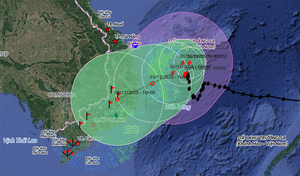
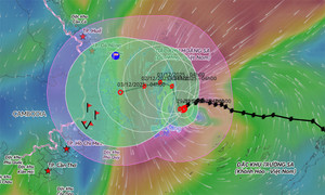
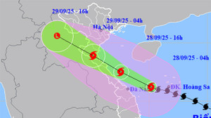
Typhoon Bualoi (Typhoon No. 10) is expected to make landfall between 0:00 and 2:00 AM on September 29th. Currently, heavy rain and strong winds are intensifying and continuing, with the area most severely affected stretching from Thanh Hoa to Quang Tri.
Border guards and the Nghe An provincial government are urgently helping people anchor their boats, reinforce their houses, and evacuate residents from dangerous areas before Typhoon Bualoi (Typhoon No. 10) makes landfall.
Due to the complex developments of Typhoon Bualoi (Typhoon No. 10), wards and communes in Nghe An province have urgently evacuated more than 2.000 people from old residential areas to safe locations.
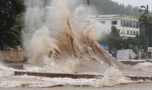
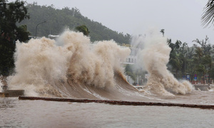
On the morning of September 28th, the embankments of Cua Lo (Nghe An) and Thien Cam (Ha Tinh) were relentlessly battered by high waves and rough seas ahead of Typhoon Bualoi's landfall.
On the morning of September 28th, the streets of Nghe An were deserted, shops and restaurants were closed, and many small traders were packing up their goods in preparation for Typhoon Bualoi (Typhoon No. 10) which was about to make landfall.
Although it hasn't made landfall yet, Typhoon Bualoi (Typhoon No. 10) has already caused tornadoes, ripping off the roofs of more than 70 houses and schools in Hue, along with other damage.
On the morning of September 28th, before Typhoon Bualoi (Typhoon No. 10) made landfall, many areas in Nghe An experienced heavy rain, causing localized flooding on some central roads.
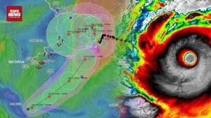
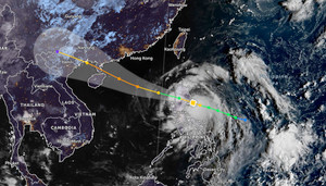
On the morning of September 28th, Typhoon Bualoi (Typhoon No. 10) maintained its intensity at level 12, with gusts reaching level 15, located 150km from Da Nang and 360km from northern Quang Tri, rapidly advancing towards the central mainland.
Forecasts indicate that Typhoon Bualoi is moving very quickly (30–35 km/h, almost double the average), is strong, has a wide area of impact, and could cause a combination of various natural disasters.
According to the Deputy Minister of Agriculture and Environment, Typhoon Bualoi (Typhoon No. 10) is moving twice as fast as a normal typhoon, becoming stronger as it approaches the coast, posing a direct threat to the North Central region.