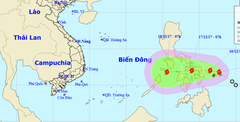
The meteorological agency issued a forecast of the path of Typhoon Mekhala, and also predicted that the typhoon's strongest intensity could reach level 12, with gusts up to level 16.
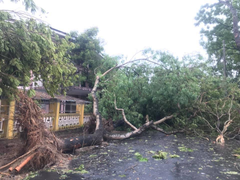
Meteorological and hydrological experts unanimously agree that Typhoon No. 5 was an unusual storm, battering the central coast for 12 hours and causing severe damage.
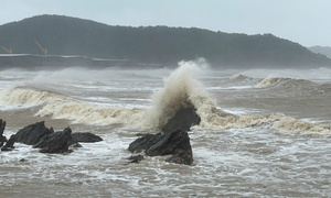
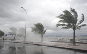
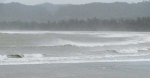
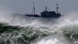
At Cua Lo beach, waves 2-3 meters high rolled ashore, and the wind howled incessantly; roads in Ha Tinh and Nghe An provinces were also deserted ahead of Typhoon No. 5's landfall.
Ahead of what is expected to be a very dangerous storm, Deputy Prime Minister Tran Hong Ha instructed local authorities to immediately issue regulations prohibiting people from going out between 11 am and 18 pm today.
The Philippine meteorological agency reported that on the morning of May 27, Super Typhoon Mawar entered the Philippine area of responsibility, with maximum sustained winds near the center of the storm reaching 195 km/h.
The National Steering Committee for Disaster Prevention and Control has requested that the Department of Disaster Response and Recovery develop two response scenarios for Typhoon No. 6 today.
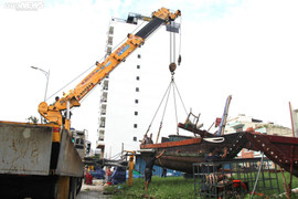
Ahead of forecasts that Noru will be a very strong typhoon entering the South China Sea tonight, September 25th, fishermen in Da Nang are urgently hiring cranes to move their boats and vessels ashore to avoid the storm.
Deputy Prime Minister Le Van Thanh noted that Typhoon Rai, upon entering the East Sea, is predicted to be very strong and have a complex trajectory, so there should be absolutely no complacency.
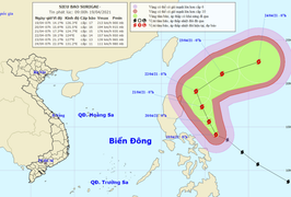
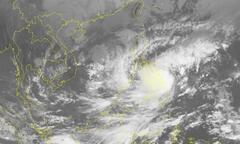
The intensity of Super Typhoon Rai has decreased by one level, reaching level 17, and is rapidly moving into the South China Sea. Near the center of the typhoon, winds are gusting at level 17, and the highest waves are 8-10 meters.
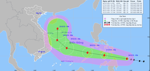
Over the next 1-2 days, Typhoon Rai will move in a west-northwest direction and enter the South China Sea, with maximum wind gusts near the center reaching level 16, before possibly changing direction towards the north.
On the morning of April 19th, the center of Super Typhoon Surigae was located approximately 270km east of the central coast of the Philippines, with maximum sustained winds near the center reaching Category 17, and gusts exceeding Category 17.
This afternoon, December 20th, the tropical depression in the East Sea strengthened into typhoon number 14 of 2020, causing gusts of wind up to level 10 and being given the international name Krovanh.
Vietnam has proposed removing the name LINFA, the name of the storm that caused devastating floods, flash floods, and landslides that severely impacted the entire central region in October.
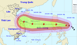
Minister Nguyen Xuan Cuong emphasized that the path of typhoon No. 13 is difficult to predict, the storm is moving at a high speed, and it is making landfall in an area that has just suffered heavy damage from 9 typhoons and 2 tropical depressions.
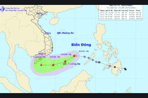
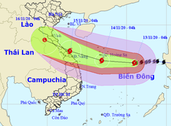
Typhoon No. 13, with wind gusts reaching level 15, is currently located approximately 450km east-southeast of the Hoang Sa archipelago and is expected to make landfall in Ha Tinh and Thua Thien Hue provinces on November 15th.
Typhoon No. 13 is forecast to enter the East Sea on the morning of November 12th, sharing many characteristics with Typhoon No. 9 and potentially causing severe damage to central Vietnam.
Dozens of hotels and villas in Hoi An City, Quang Nam province, voluntarily opened their doors to welcome nearly 400 local residents seeking shelter from Typhoon No. 9.
When a storm makes landfall, people need to stay put, avoid going outside, refrain from parking under large trees, turn off main power sources, move belongings to higher ground, and follow evacuation orders.
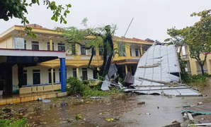
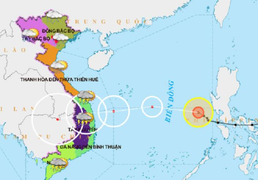
Typhoon No. 9 is assessed to have devastating destructive power, with wind speeds reaching approximately level 11-12 upon landfall, gusting to level 15, and weak-structured houses at risk of being destroyed.
Given the possibility of Typhoon Tembin continuing to strengthen and entering the East Sea, the Central Steering Committee for Disaster Prevention and Control has issued an urgent dispatch requesting a ban on sea travel no later than 4 PM on December 23, 2017.
On the morning of December 14th, the tropical depression located east of central Philippines strengthened into a typhoon and was given the international name Kai-tak.
Typhoon No. 7 will make landfall within the next 36 to 48 hours, and heavy rain is expected in the northeastern provinces from this evening (October 18) until early morning on October 20.
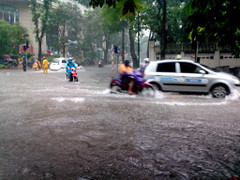
Experts predict that Ho Chi Minh City may still experience heavy rain this evening (September 27), but it is unlikely to repeat the amount of rainfall seen the previous day.
The storm, internationally named MEGI, is currently active in the waters off the far northeast coast of Lu-Dong Island (Philippines), with winds gradually increasing to force 6-7, gusting to force 8-9, and rough seas.