The Pa Thơm suspension bridge (Thanh Yên commune, Điện Biên province) suffered a cable break, causing a pickup truck carrying commune officials on a storm preparedness inspection and a motorbike to fall into the river.
Typhoon No. 3 is about 10km from Hung Yen, 25km from Ninh Binh, and is about to make landfall. Heavy rain is forecast to continue in the North until the end of the week.
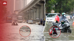
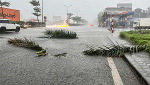
Heavy rains caused by Typhoon No. 3 have resulted in severe flooding in many streets in Sam Son, Thanh Hoa, paralyzing traffic, closing shops, and leaving the streets deserted.
Due to the complex developments of Typhoon No. 3, banks have announced the temporary suspension of operations at some branches/transaction offices in Hanoi, Hai Phong, Quang Ninh, Hung Yen, and Ninh Binh.
Typhoon Wipha (Typhoon No. 3) has approached the Vietnamese mainland. Experts have offered their assessments regarding the timing and intensity of the typhoon's landfall in Hai Phong and Ninh Binh.
Residents of the G6A Thanh Cong apartment building were encouraged and organized to evacuate by the Giang Vo Ward People's Committee on the night of July 21st to avoid Typhoon Wipha (Typhoon No. 3).
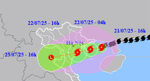
Forecast for 10-14h today: Typhoon Wipha (Typhoon No. 3) will make landfall south of Hai Phong - Ninh Binh, with intensity level 8-9, gusts level 11-12, bringing continued heavy to very heavy rain to Northern and North Central Vietnam.
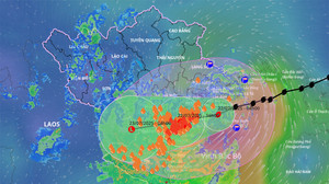
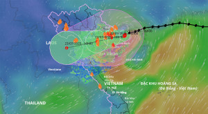
Many websites and applications provide storm data from international forecasting models, helping users track the path of Typhoon Wipha (Typhoon No. 3).
Typhoon Wipha is strengthening, potentially reaching the upper end of Category 10 or the beginning of Category 11, bringing heavy rain to Northern and North Central Vietnam, particularly in Hung Yen, Ninh Binh, southern Phu Tho, Thanh Hoa, and Nghe An.
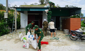
A 300-meter-long crack has appeared on Pha Mat Mountain (Nghe An province), forcing authorities to urgently relocate 19 households in the dangerous area to safety before typhoon No. 3 makes landfall.
Deputy Prime Minister Tran Hong Ha inspected the storm response efforts in Hung Yen province, noting that the locality needs to pay special attention to the tidal surge coinciding with the storm's landfall.
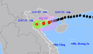
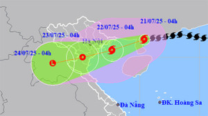
Forecasts indicate that around noon to afternoon tomorrow, July 22nd, the center of Typhoon Wipha (Typhoon No. 3) will move inland into the provinces from Hai Phong to northern Thanh Hoa.
Hanoi will be affected by Typhoon Wipha (Typhoon No. 3), bringing heavy rain and posing a high risk of flooding in many urban areas and inner-city streets.
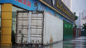
Many seafood business owners in Quang Ninh decided to invest tens of millions of dong to rent containers and trucks to block their entrances before Typhoon Wipha made landfall.
The Hanoi Department of Culture and Sports has just issued a document on disaster prevention at historical and cultural relics and scenic spots in Hanoi to cope with typhoon No. 3.
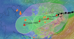
Typhoon Wipha (Typhoon No. 3) is currently about 100km from Quang Ninh province and is forecast to continue strengthening, reaching levels 10-11 with gusts up to level 14 before making landfall.
Forecast for July 22nd: Typhoon Wipha (Typhoon No. 3) will make landfall in the coastal areas from Hai Phong to Thanh Hoa with a strength of level 9-10, bringing heavy rain to the Northern region, Thanh Hoa and Nghe An.
The Ministry of Health has instructed hospitals in the northern and central regions to proactively evacuate patients and be prepared to respond to the complex developments of Typhoon Wipha (Typhoon No. 3).
Forecasts indicate that when the center of typhoon Wipha (Typhoon No. 3) is over the sea area from Hai Phong to Thanh Hoa, it will maintain winds of level 10-11, potentially causing ships to sink, trees toppled, power poles to fall, and roofs to be ripped off...
Given the complex developments of Typhoon No. 3, Hanoi police are intensifying inspections along the Red River, assisting residents in anchoring boats, reinforcing floating houses, and preparing evacuation plans.
Typhoon No. 3 has intensified again after entering the Gulf of Tonkin, with forecasts predicting increased rainfall from this evening and peaking from tonight to tomorrow morning as the storm's center approaches the Vietnamese coast.
Given the complex developments of Typhoon No. 3, the provinces of Thanh Hoa, Nghe An, and Ha Tinh have decided to ban sea travel, and people are making efforts to implement storm prevention measures.
Typhoon Wipha (Typhoon No. 3) reached level 11 and entered the Gulf of Tonkin, approximately 190km from Quang Ninh at 10:00 AM. The typhoon is expected to intensify in the next 24 hours, causing heavy rain and flooding in Northern and North Central Vietnam.
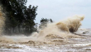
Typhoon Wipha (Typhoon No. 3) has entered the Gulf of Tonkin, bringing very bad weather to the sea, with many areas experiencing severe rough seas and waves reaching up to 5 meters high.
Typhoon No. 3 is currently at level 9, with gusts up to level 12, located 233km from Hai Phong-Quang Ninh, and may intensify in the next 24 hours, causing heavy rain in Northern and North Central Vietnam.
The Prime Minister requested ministries to form working groups to coordinate with five localities in directing the response to Typhoon No. 3, including Quang Ninh, Hai Phong, Ninh Binh, Hung Yen, and Thanh Hoa.
When a tourist boat sank in Thien Cam Bay after being hit by a storm, 34 people on board quickly put on life jackets and jumped into the sea, where they were rescued by large fishing boats.