
Typhoon Kalmaegi (Typhoon No. 13) tossed a man against a wall.
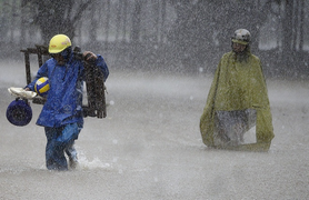
On the afternoon of November 6th, extremely strong winds from Typhoon Kalmaegi (Typhoon No. 13) sent a man flying into a wall in Buon Ma Thuot, Dak Lak.
On the afternoon of November 6th, extremely strong winds from Typhoon Kalmaegi (Typhoon No. 13) sent a man flying into a wall in Buon Ma Thuot, Dak Lak.

On October 20th, Typhoon Fengshen was located in the eastern part of the North East Sea, moving northwest at a speed of approximately 20-25 km/h, with the potential to intensify.

According to the Philippine government, at least six people were killed and 22 others injured after Typhoon Bebinca made landfall in the country.

In Sichuan province, China, strong winds tore apart numerous corrugated iron roofing sheets, scattering debris throughout the streets.
A tropical depression is currently active east of the Philippines and is forecast to strengthen into a typhoon, with a 60-70% chance of entering the northern South China Sea next week.

Experts predict a possibility of Typhoon No. 3 forming in the East Sea during the upcoming National Day holiday on September 2nd.

From now until the end of 2023, the number of typhoons and tropical depressions active in the South China Sea, as well as affecting the mainland, is likely to be lower than the multi-year average.
Meteorological experts consider Mawar to be the strongest super typhoon recorded since 2021, with wind gusts reaching up to 270 km/h.

An 8-year-old Chinese girl's "revenge diary" dedicated to her older sister has become a hot topic of discussion among netizens in the country because it's so adorable.

Most Shanghai residents had to stay home on July 26 due to the impact of Typhoon Infa, which destroyed more than 4.700 trees and disrupted the city's power supply.

A moment captured of a rat gliding across a piece of floating wood amidst floodwaters during the monsoon season has gone viral in the Philippines.
Vietnam has proposed removing the name LINFA, the name of the storm that caused devastating floods, flash floods, and landslides that severely impacted the entire central region in October.
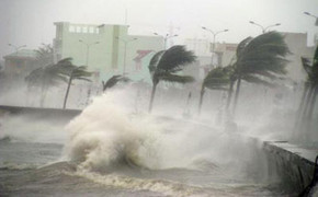
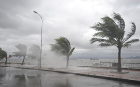
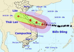
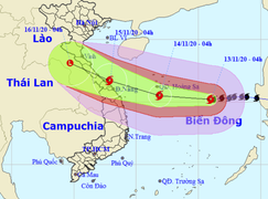
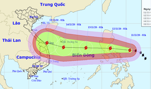
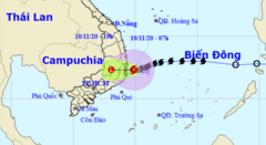
On the evening of November 14th, the center of Typhoon No. 13 was approximately 80km from Da Nang, with the strongest winds near the center reaching level 10 (90-100km/hour), gusting to level 12.
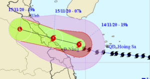
On the evening of November 14th, the center of Typhoon No. 13 was located approximately 130km from Da Nang-Thua Thien Hue, with maximum wind speeds near the center reaching level 11 (100-115km/hour), gusting to level 14.

On the afternoon of November 14th, Typhoon No. 13 was approximately 187km from Da Nang and 280km from Thua Thien Hue, with maximum wind speeds near the center of the typhoon reaching levels 12-13, gusting to level 16.

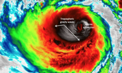
Experts explain why Typhoon No. 13 unexpectedly intensified by two levels on the night of November 13th, with wind gusts reaching level 17.
The Prime Minister has just issued a directive instructing an emergency response to Typhoon No. 13, requesting relevant ministries, agencies, and localities to suspend unnecessary meetings.
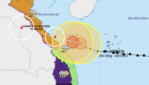
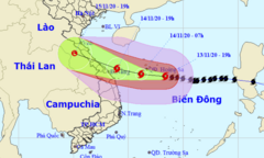
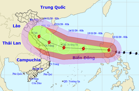
Typhoon No. 13 is located approximately 300km from Da Nang - Thua Thien Hue, with maximum wind speeds near the center of the storm reaching level 13-14 (135-165 km/hour), and gusts up to level 17.
Early morning on November 14th, Typhoon No. 13 continued to strengthen, with maximum wind speeds of level 13-14 (135-165 km/hour), gusts up to level 17, and is heading towards the provinces from Da Nang to Thua Thien Hue.

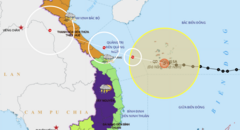
Five airports – Vinh, Chu Lai, Phu Bai, Dong Hoi, and Da Nang – will be closed on November 14-15 due to the impact of Typhoon No. 13.
On the evening of November 13th, Typhoon No. 13 (Vamco) intensified to level 13, with gusts reaching level 16, located approximately 190km from the Hoang Sa archipelago and heading towards the provinces from Ha Tinh to Quang Nam.

Minister Nguyen Xuan Cuong emphasized that the path of typhoon No. 13 is difficult to predict, the storm is moving at a high speed, and it is making landfall in an area that has just suffered heavy damage from 9 typhoons and 2 tropical depressions.
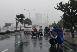
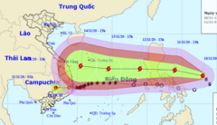
Typhoon No. 13 is forecast to make landfall on November 15th, but starting tomorrow it will cause heavy to very heavy rain in provinces from Ha Tinh to Quang Nam.
Typhoon No. 13, with wind gusts reaching level 15, is currently located approximately 450km east-southeast of the Hoang Sa archipelago and is expected to make landfall in Ha Tinh and Thua Thien Hue provinces on November 15th.
On the afternoon of November 12th, Typhoon No. 13 was located approximately 640km east-southeast of the Hoang Sa archipelago, with maximum wind speeds near the center of the storm reaching level 12, gusting to level 15.
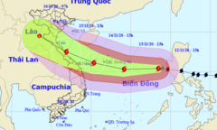
On the afternoon of November 12th, Typhoon No. 13 was located approximately 700km east-southeast of the Hoang Sa archipelago, with gusts reaching level 15, and heading towards the provinces from Ha Tinh to Quang Nam.
Today (November 12th), Typhoon Vamco, with gusts reaching level 15, entered the East Sea, while the central provinces are experiencing widespread heavy rain.
Typhoon Vamco is intensifying, making landfall in the Philippines and will move into the South China Sea with wind gusts reaching level 14.
On the afternoon of November 10th, Typhoon No. 12 weakened into a tropical depression, while Typhoon Vamco was approaching the East Sea and will become Typhoon No. 13 affecting our country.
Before typhoon No. 12 made landfall, the provinces from Thua Thien Hue to Khanh Hoa experienced heavy to very heavy rain with rainfall amounts generally ranging from 100-200mm, and in some places reaching up to 251mm.